| Home | City Bus | Maps | Villages | Cities | Rail | Tourist Places | School | College | Pin Codes | Corona Cases Count |
| Distance Calculator Bus Services IFSC Codes Trace Mobile Number Weather Search Place Trace IP Available Cash ATM/Banks Locate Polling Booth Report an Error contact People Surnames |
Head Quarters : Serchhip
Language : Mizo
Area: 1422 sq. km
Population : 64875
Sex Ratio : 976
Density : 46/ sq. km
Literacy : 98.76
Elevation / Altitude: - meters. Above Seal level
Current Time 06:19 AM
Date: Tuesday , Jun 02,2026 (IST)
Time zone: IST (UTC+5:30)
District Pin code Index: 796XXX
Vehicle Registration Number: MZ-06
RTO Office: Serchhip
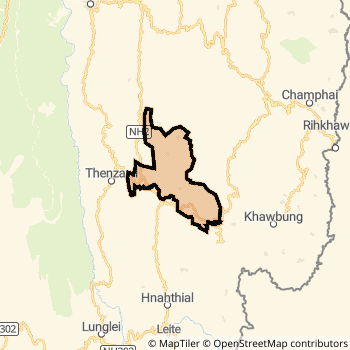
Serchhip District Map
Current Corona Virus Infected Patients Count in Serchhip District
| City Name | District Name | Total Covid cases |
|---|
Temples in Serchhip
Historical Daily Min/Max Temperatures (Next 7 Days)
| Years | 01 Jun | 02 Jun | 03 Jun | 04 Jun | 05 Jun | 06 Jun | 07 Jun |
|---|---|---|---|---|---|---|---|
| 2025 | |||||||
| 2024 | |||||||
| 2023 |
About Serchhip District
Serchhip District is one among 8 Districts of Mizoram State ,India. Serchhip District Administrative head quarter is Serchhip. It is is Located 58 KM North towards State capital Aizawl . Serchhip District population is 64875. It is 7 th Largest District in the State by population.Geography and Climate Serchhip District
It is Located at Latitude-23.3, Longitude-92.8. Serchhip District is sharing border with Lunglei District to the South . Serchhip District occupies an area of approximately 1422 square kilometres. . Its in the meters to meters elevation range.This District belongs to Eastern India .DemoGraphics of Serchhip District
Mizo is the Local Language here. Serchhip District is divided into 2 Blocks , 44 Panchayats , 44 Villages. Serchhip Block is the Smallest Block by population with 258 population. East Lungdar Block is the Biggest Block by population with 545 population.Census 2011 of Serchhip District
Serchhip district Total population is 64875 according to census 2011.Males are 32831 and Females are 32044 .Literate people are 42921 among total.Its total area is 1422 sq.km. It is the 7 th largest district in the state by Population . But 6 th Largest District in the state By Area. 608 th Largest District in the Country By Population. 1 st highest District in the State By literacy rate. 1 st highest District in the Country By literacy rate.its literacy Rate is 98.76Politics in Serchhip District
Mizo National Front , INC are the major political parties in Serchhip District.Assembly constituencies in Serchhip District
Total 2 Assembly constituencies in Serchhip District.| Constituency name | MLA name | Party |
|---|---|---|
| Tuikum | P.C. Vanlalruata | |
| Hrangturzo | Lalmuanpuia Punte |
Parliament constituencies in Serchhip District
Total 1 Parliament constituencies in Serchhip District.| Constituency name | MP name | Party |
|---|---|---|
| Mizoram | C LALROSANGA | Mizo National Front |
Serchhip District Political Map
Serchhip Commerce
Total Registered Comapnies with Ministry of Corporate Affairs (MCA) in Serchhip areCompany Name : MIZO ORGANICS SERCHHIP FARMER PRODUCER C OMPANY LIMITED
Type Of Business : Agriculture and Allied Activities
Capital : 0
More Serchhip Registered Companies
Serchhip District Tourism
Serchhip , are the Tourist destinations to Visit.
Serchhip Transport
Road Transport
District Headquarters Serchhip is well connected by road . Serchhip is about 58 KM by road to Aizawl( Capital of Mizoram )Rail Transport
Bus Transport
Mizoram State Road Transportation ( MST) runs Busses from Major cities to Towns and Villages in this District.
Hotels in Serchhip
Near Cities
Lunglei 50 KM near
Champhai 57 KM near
Aizawl 58 KM near
Saiha 100 KM near
Near By Air Ports
Aizawl Airport 72 KM near
Singerbhil Airport 198 KM near
Kumbhirgram Airport 201 KM near
Imphal Municipal Airport 217 KM near
Near By Districts
Serchhip 0 KM near
Lunglei 51 KM near
Champhai 56 KM near
Aizawl 58 KM near