| Home | City Bus | Maps | Villages | Cities | Rail | Tourist Places | School | College | Pin Codes | Corona Cases Count |
| Distance Calculator Bus Services IFSC Codes Trace Mobile Number Weather Search Place Trace IP Available Cash ATM/Banks Locate Polling Booth Report an Error contact People Surnames |
Head Quarters : Nabarangpur
Language : Oriya and Hindi
Area: 5294 sq. km
Population : 1218762
Sex Ratio : 1018
Density : 230/ sq. km
Literacy : 48.2
Elevation / Altitude: 662 - 241 meters. Above Seal level
Current Time 07:46 AM
Date: Monday , May 18,2026 (IST)
Time zone: IST (UTC+5:30)
District Pin code Index: 764XXX
Vehicle Registration Number: OR-24
RTO Office: Nabarangpur
Tourist Places near Nabarangpur
Jeypore Jagdalpur Bastar Kalahandi (Kalahani) Araku Valley (Araku Loya) Ananthagiri
Jeypore Jagdalpur Bastar Kalahandi (Kalahani) Araku Valley (Araku Loya) Ananthagiri
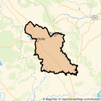
Nabarangpur District Map
Current Corona Virus Infected Patients Count in Nabarangpur District
| City Name | District Name | Total Covid cases |
|---|
Nabarangpur Live Weather
Temperature: 26.4 °C
overcast clouds
Humidity: 63%
Wind : 2.2 mt/sec towards W
StationName : "KotapÄ\u0081rh"
observed on 2 Hours Back
Temperature: 26.4 °C
overcast clouds
Humidity: 63%
Wind : 2.2 mt/sec towards W
StationName : "KotapÄ\u0081rh"
observed on 2 Hours Back
Nabarangpur Weather Forecast for Next 5 days
19-05-2026
26.2°C to 38.4°C
overcast clouds, scattered clouds, broken clouds
26.2°C to 38.4°C
overcast clouds, scattered clouds, broken clouds
20-05-2026
25.9°C to 41.8°C
broken clouds, scattered clouds, light rain, few clouds
25.9°C to 41.8°C
broken clouds, scattered clouds, light rain, few clouds
21-05-2026
27.8°C to 44.7°C
scattered clouds, few clouds, clear sky, broken clouds
27.8°C to 44.7°C
scattered clouds, few clouds, clear sky, broken clouds
22-05-2026
28.3°C to 44.6°C
broken clouds, few clouds, clear sky, scattered clouds, overcast clouds
28.3°C to 44.6°C
broken clouds, few clouds, clear sky, scattered clouds, overcast clouds
Temples in Nabarangpur
Historical Daily Min/Max Temperatures (Next 7 Days)
| Years | 17 May | 18 May | 19 May | 20 May | 21 May | 22 May | 23 May |
|---|---|---|---|---|---|---|---|
| 2025 | 26.0°C/ 26.0°C | 34.0°C/ 27.0°C | 30.0°C/ 26.0°C | 32.0°C/ 28.0°C | 29.0°C/ 24.0°C | 35.0°C/ 24.0°C | 29.0°C/ 27.0°C |
| 2024 | 29.0°C/ 23.0°C | 29.0°C/ 24.0°C | 32.0°C/ 28.0°C | 35.0°C/ 29.0°C | 39.0°C/ 27.0°C | 30.0°C/ 26.0°C | 41.0°C/ 27.0°C |
| 2023 | 41.0°C/ 29.0°C | 38.0°C/ 27.0°C | 32.0°C/ 26.0°C | 37.0°C/ 25.0°C | 31.0°C/ 28.0°C | 38.0°C/ 27.0°C | 39.0°C/ 33.0°C |
About Nabarangpur District
Nabarangpur District is one among 30 Districts of Odisha State ,India. Nabarangpur District Administrative head quarter is Nabarangpur. It is is Located 423 KM East towards State capital Bhubaneswar . Nabarangpur District population is 1218762. It is 17 th Largest District in the State by population.Geography and Climate Nabarangpur District
It is Located at Latitude-19.2, Longitude-82.5. Nabarangpur District is sharing border with Bastar District to the west , Kalahandi District to the North , Koraput District to the South . It is sharing Border with Chattisgarh State to the North . Nabarangpur District occupies an area of approximately 5294 square kilometres. . Its in the 662 meters to 241 meters elevation range.This District belongs to Eastern India .DemoGraphics of Nabarangpur District
Oriya is the Local Language here. Also People Speaks Hindi . Nabarangpur District is divided into 10 Tehsils , Panchayats , 1597 Villages.Census 2011 of Nabarangpur District
Nabarangpur district Total population is 1218762 according to census 2011.Males are 603945 and Females are 614817 .Literate people are 806333 among total.Its total area is 5294 sq.km. It is the 17 th largest district in the state by Population . But 14 th Largest District in the state By Area. 387 th Largest District in the Country By Population. 29 th highest District in the State By literacy rate. 615 th highest District in the Country By literacy rate.its literacy Rate is 48.2Politics in Nabarangpur District
BJD , INC are the major political parties in Nabarangpur District.Assembly constituencies in Nabarangpur District
Total 4 Assembly constituencies in Nabarangpur District.| Constituency name | MLA name | Party |
|---|---|---|
| Umarkote | subash gond | BJD |
| Jharigam | ramesh chandra majhi | BJD |
| Nabarangpur | manohar randhari | BJD |
| Dabugam | bhujabal majhi | INC |
Parliament constituencies in Nabarangpur District
Total 1 Parliament constituencies in Nabarangpur District.| Constituency name | MP name | Party |
|---|---|---|
| Nabarangpur | RAMESH CHANDRA MAJHI | Biju Janata Dal |
Nabarangpur District Political Map
Nabarangpur Commerce
Total Registered Comapnies with Ministry of Corporate Affairs (MCA) in Nabarangpur are 23Company Name : HIGH RICE MANUFACTURERS PRIVATE LIMITED
Type Of Business : Manufacturing (Food stuffs)
Capital : 10.0 Lakhs
Company Name : WAY MOTERS PRIVATE LIMITED
Type Of Business : Trading
Capital : 10.0 Lakhs
Company Name : NABARANGPUR STARCH AND CHEMICALS PRIVATE LIMITED
Type Of Business : Manufacturing (Food stuffs)
Capital : 9.6 Lakhs
Company Name : UMASANKAR SABUJ DUNIA LIMITED
Type Of Business : Agriculture and Allied Activities
Capital : 5.0 Lakhs
More Nabarangpur Registered Companies
Nabarangpur District Tourism
Nabarangpur Transport
Road Transport
District Headquarters Nabarangpur is well connected by road . Nabarangapur , Umarkote are the Cities in this district having road connectivity to major towns and remote villages. Nabarangpur is about 423 KM by road to Bhubaneswar( Capital of Odisha )Rail Transport
Bus Transport
Orissa State Road Transport Corporation ( OSRTC) runs Busses from Major cities to Towns and Villages in this District.
Pin Codes in Nabarangpur District
764078
( Dongerbheja ) ,
764085
( Khatiguda ) ,
764070
( Tentulikhunti ) ,
764077
( Chandahandi ) ,
764063
( Mirganiguda ) ,
764073
( Umerkote ) ,
764061
( Kosagumuda ) ,
764075
( Kodinga ) ,
764049
( Anchalgumma ) ,
764072
( Dabugam ) ,
764071
( Papadahandi ) ,
764076
( Jharigam ) ,
764059
( Nabarangpur ) ,
764074
( Raighar ) ,
more PinCodes
Hotels in Nabarangpur
BusStops in Nabarangpur Lakes in Nabarangpur Temples in Nabarangpur Shops in Nabarangpur Nabarangpur Hospitals Hotel/Restaurants in Nabarangpur Nabarangpur RailwayStations Nabarangpur BusStops ATM in Nabarangpur
Near Cities
Nabarangapur 1 KM near
Jeypur 45 KM near
Koraput 53 KM near
Jagdalpur 64 KM near
Near By Air Ports
Vishakhapatnam Airport 202 KM near
Raipur Airport 261 KM near
Rajahmundry Airport 278 KM near
Vijayawada Airport 395 KM near
Near By Districts
Nabarangpur 0 KM near
Koraput 55 KM near
Bastar 74 KM near
Rayagada 100 KM near